The ultimate success of the California Undersea Imagery Archive is predicated on the use of its imagery for new research projects designed to enhance our understanding of the state’s subtidal ecosystems and the management of those ecosystems. Imagery can be mined to answer questions that are consistent with the original intent of the project that collected it (e.g., a study of rockfish density within a marine protected area), or entirely new questions (e.g., the coast-wide distribution and habitat utilization of Lingcod). New projects might utilize imagery from a single location, or draw imagery from across multiple locations.
Below is a representative subset of projects conducted using archived imagery to-date.
New questions can produce new scientific leaps. They can tiddlywink new flips of insight and understanding. Big ones. Paradigm shifts. (Howard Bloom)
| Title |
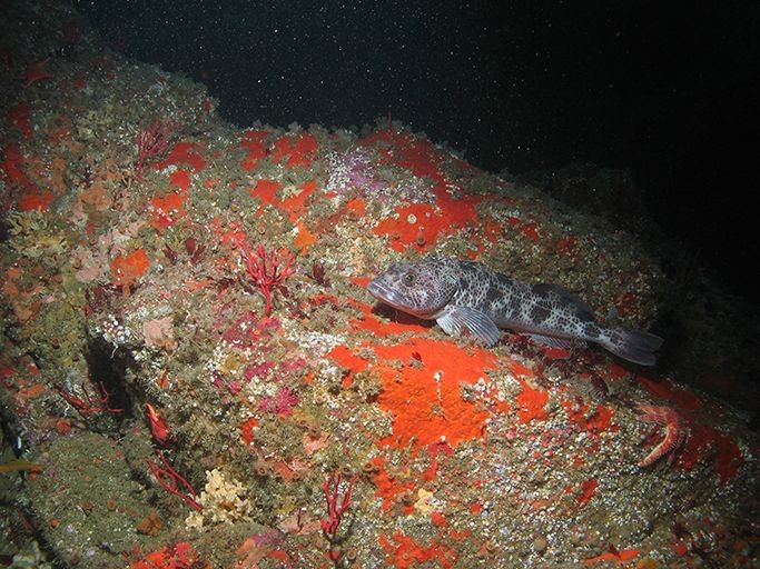
Lingcod (Ophiodon elongatus) habitat association in California: implications for conservation and management |
| Authors |
Megan Bassett, James Lindholm, Corey Garza, Rikk Kvitek & Deb Wilson-Vandenberg |
| Year |
2017 |
| Journal |
Environmental Biology of Fishes |
| Summary |
Video of the seafloor that had been collected from several projects in North-Central California were analyzed to investigate lingcod habitat utilization. ROV and towed camera sled derived underwater video imagery were coupled with high-resolution bathymetry data and evaluated using Generalized Linear Models to investigate: a) how Lingcod are distributed relative to seafloor habitats along California’s central coast, b) the extent to which any ontogenetic patterns varied across habitats, and c) how associations based on visual observations compare to those from landscape modeling analysis. The results of this study clearly depicted an ontogenetic shift in Lingcod habitat utilization. Lingcod shifted from primarily low relief, soft sediments as young to mixed substrates at intermediate ages and ultimately to primarily harder substrates as adults. These results are important in the context of on-going marine spatial planning wherein further information on the habitat associations of targeted species can allow for more refined management. |
| Broader Significance |
This project extracted valuable fishery data from a compilation of video footage that had been collected by different, unrelated original research projects. Considering the high cost of gathering undersea video, that is often only used in the project it was collect for, projects such as this demonstrate the value of the untapped data lying within the video footage from the projects housed in archives such as the CUIA. |
| Title |
Patterns in the local distribution of the Sea Whip, Halipteris willemoesi, in an area impacted by mobile fishing gear |
| Authors |
James Lindholm, Megan Kelly, Donna Kline, Jean de Marignac |
| Year |
2008 |
| Journal |
Marine Technology Society Journal |
| Summary |
While conducting a larger project along the continental shelf off central California in June 2006, we encountered a large patch of sea whips (Halipteris willemoesi) in an area that was actively fished by vessels using otter trawls. A total of 10 transects were conducted using a remotely operated vehicle (ROV) to collect video imagery of seafloor communities. Video records allowed us to quantify sea whip density and to calculate the densities of upright and damaged or broken sea whips. Though the transects were sited within a dense aggregation of trawl tracks, we recorded significant variability in sea whip densities across transects. While subtle differences in water depth among transects may have contributed to the variability in sea whip density, we suggest that the distribution of trawling effort is a more likely explanation. |
| Broader Significance |
A variety of organisms, including rockfish, sea horses, weathervane scallops and basket stars have been observed to associate with H. willemoesi or other pennatulid species. As attributes of animal habitat, sea whips may provide cover from predation and facilitate animal feeding higher in the water column. The vulnerability of the H. willemosi to impacts from trawling activity remains unclear. Studies of age and growth indicate that sea whip life spans may exceed 50 yrs, indicating that any impacts from trawling could persist for decades. This study sought to fill part of the knowledge gap on whether or not fishing activity does impact these organisms that provide habitat to many other species. |
| Title |
An approach to the collection, processing, and analysis of towed camera video imagery for marine resources management |
| Authors |
Ashley Knight, James Lindholm, Andrew DeVogelaere, Fred Watson |
| Year |
2014 |
| Journal |
Marine Technology Society Journal |
| Summary |
A variety of video and photographic imaging platforms are used to survey seafloor habitats and organisms beyond the effective depth of most SCUBA diving (>30 m). Each platform has benefits and shortcomings, with the most frequently limiting factors being (a) access to the most advanced instruments, (b) response of organisms, and (c) resolution of organism identification. Here, we describe the approaches used to collect, process, and analyze video imagery collected with a simple towed camera sled in the Monterey Bay National Marine Sanctuary as part of a larger, ongoing characterization project that began in 2006. We describe the details of deployment, imagery collection, postprocessing, and analyses gleaned from hundreds of hours of underwater video. Data extracted from camera sled imagery have been analyzed using multivariate model comparison techniques and have been represented in a variety of forms to support management needs and public outreach efforts. |
| Broader Significance |
Video surveys of seafloor habitats and organisms beyond the effective depth of SCUBA operations are becoming increasingly important for marine conservation monitoring and management efforts. It is essential to researchers that they understand the shortcomings and strengths of each platform they may use to gather this data prior to their deployment. |
| Title |
Ecological effects of bottom trawling on the structural attributes of fish habitat in unconsolidated sediments along the central California outer continental shelf |
| Authors |
James Lindholm, Mary Gleason, Donna Kline, Larissa Clary, Steve Rienecke, Alli Cramer, Marc Los Huertos |
| Year |
2015 |
| Journal |
Fishery Bulletin, NOAA NMFS |
| Summary |
Bottom trawling has been shown to affect the seafloor and associated biological communities around the world. Considerably less is known about the dynamics of impacts to structural attributes of fish habitat, particularly in unconsolidated sandy sediments of the continental shelf. We collaborated with commercial fishermen to conduct experimental trawls, with the type of small-footrope trawl required for trawling on the continental shelf, along the 170-m isobath in an area off Morro Bay in central California. The bottom trawling intensity we applied was based on the historical range of fishing effort in the study area and included low-intensity and high-intensity treatments. A remotely operated vehicle was used to collect continuous video and still photographs in trawled and in untrawled control plots, before trawling and at 2 weeks, 6 months, and 1 year after trawling. Scour marks from the heavy doors of the trawl were observed in the seafloor and persisted for at least a year. Although data extracted from the collected imagery showed some smoothing of the seafloor in trawled plots, the minimal differences between trawled and control plots in microtopographic structure on the seafloor were statistically significant only during one sampling period. Further, there were no significant differences between trawled and untrawled plots with respect to structure-forming invertebrates (e.g., sea whips) and mobile invertebrates (e.g., sea stars). The results of our study, part of ongoing efforts to understand and manage fishing impacts, indicate that bottom trawling with a small-footrope gear may have limited effects in some sand habitats.
|
| Broader Significance |
This project shows that a fine tuned approach is necessary for management of the commercial bottom trawl fishery by demonstrating that soft bottomed habitat may not show any ecological differences after experiencing trawling. An area such as the study site may be able to withstand greater fishing effort, and the findings from this study may inform future Federal groundfish fishery management decisions. This study also demonstrates how ROV image observations may also be used to produce quantifiable ecological measurements. |
| Title |
Vertical stratification in the distribution of demersal fishes along the walls of the La Jolla and Scripps submarine canyons, California, USA |
| Authors |
Joshua G. Smith and James Lindholm |
| Year |
2016 |
| Journal |
Continental Shelf Research |
| Summary |
The active continental margin of the California coast is cut by eight submarine canyons, several of which extend from the shore to the deep abyssal plain. We sampled the demersal fish assemblages in two of those canyons: (1) the Scripps submarine canyon in the San Diego Scripps State Marine Conservation Area (SMCA) and (2) the La Jolla canyon in the Matlahuayl State Marine Reserve(SMR) to gain insight into both the distributions and habitat associations of demersal fishes in canyons. A remotely operated vehicle was used to conduct 21 vertically oriented transects along the canyon walls in depths ranging from 20 to 300 m. Species composition was assessed in three depth-stratified zones (100 m per zone) along the canyon walls. Species richness, abundance, and attributes of the surrounding canyon habitat structure (slope and benthic terrain ruggedness)were quantified. Three distinct assemblage groupings were identified, which comprised 35 species of demersal fishes from 17 families. Among all factors analyzed in this study, depth, slope, and ruggedness were strong explanatory variables of patterns of species richness and abundance; however, the relationship between depth and assemblage structure was non-linear. The greatest number of species was observed in the mid depth-stratified zone. These trends suggest that variation in canyon dynamics across depth strata may facilitate distinct assemblage groupings of demersal fishes, which can in turn be used to better manage these unique habitats. |
| Broader Significance |
The geographic distributions of many coastal marine fish assemblages are strongly driven by habitat features, particularly among demersal fishes that live along the seafloor. Ecologists have long recognized the importance of characterizing fish habitat associations, especially where spatial management is under consideration. However, little is known about fish distribution sand habitat suitability in unique demersal habitats such as submarine canyons. Effective management of species requires an accurate understanding of their habitat and where they aggregate. This study provides insight into one such habitat, submarine canyons, and may be applied in further fine scale habitat characterizations. |