Geospatial Resources
Software
Geospatial software available to students, staff, and faculty on CSUMB teaching lab workstations and for use on their own personal computers.

CSUMB subscribes to the CSU GIS Specialty Center's Esri Site License, securing access to Esri's entire ArcGIS Platform of desktop, server, and online GIS software for academic, research, and administrative use.
Vendor description:
ArcGIS is your first step toward better, smarter decision making and a more efficient organization. Just about every problem and situation has a location aspect. Unlock the power of location with ArcGIS.
ArcGIS for Desktop
ArcGIS for Desktop is now available only as ArcGIS Pro. ArcGIS is only available for the Windows operating system. To run ArcGIS on a Mac, Windows must be installed first.
ArcGIS Pro
ArcGIS for Desktop: ArcGIS Pro is installed in all teaching and common-use Windows computer labs at CSUMB.
CSUMB students, staff, and faculty can download ArcGIS Pro from profile section of their CSUMB Education and Research AGOL Organization account.
The licensing for ArcGIS Pro is administered via the user's ArcGIS Online (AGOL) and Esri accounts ("Named User" licensing). CSUMB community members can obtain a license for ArcGIS Pro via their CSUMB Education and Research AGOL Organization account (see below), or contact gis@csumb.edu for other options.
Authorizing ArcGIS Pro: Named User License
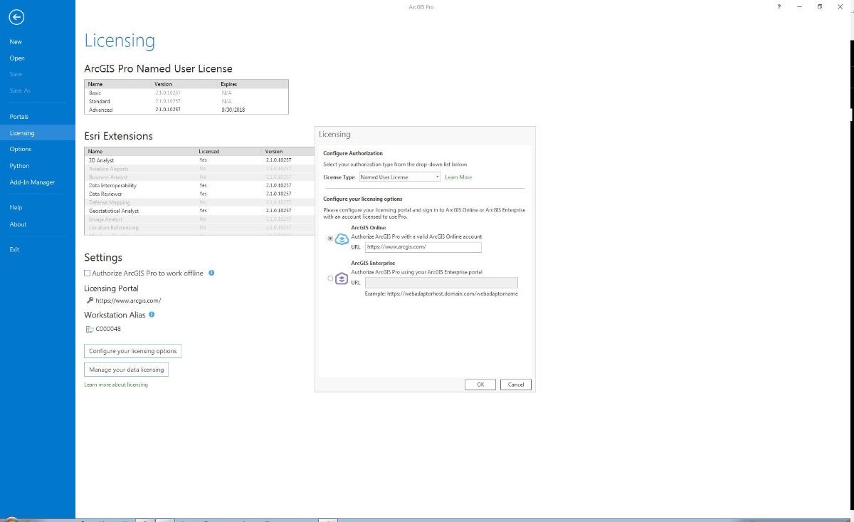
You will need an account with the CSUMB Education and Research AGOL Organization that is authorized for Pro.
Contact your instructor or gis@csumb.edu if you do not have an AGOL account.
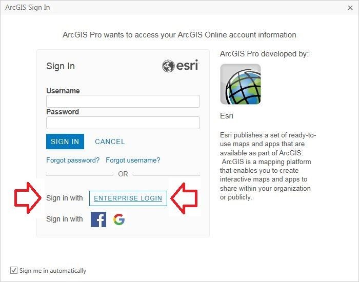
Be sure to choose "Sign in with ENTERPRISE LOGIN":
Next, enter "csumb" in the URL for our AGOL organization:
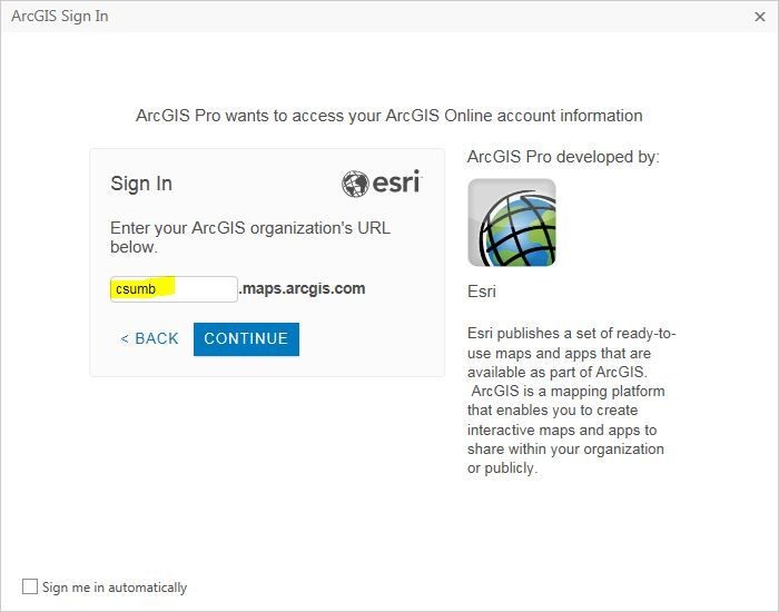
And finally enter your username and password into Okta if you are not already logged in via Single Sign On.
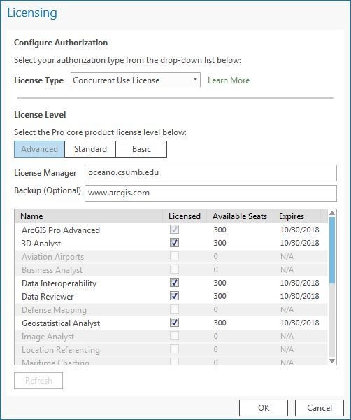
Authorizing ArcGIS Pro: Concurrent Use License
You must be connected to the CSUMB network to authorize via Concurrent Use licensing.
ArcGIS Online (AGOL)
ArcGIS Online offers a complete, cloud-based geographic information system of the world. CSUMB students, staff, and faculty can access the CSUMB Education and Research AGOL Organization account via Okta Single Sign On.
Note: CSUMB AGOL users with accounts prior to November 21, 2017 can still access their existing accounts using their old user name and password, as well as creating a new account linked to their username. You will see two sign in options when you connect to AGOL:
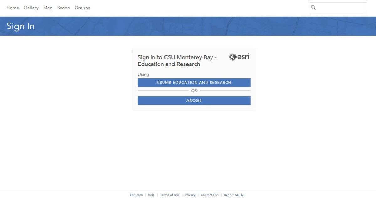
The first option, "CSUMB EDUCATION AND RESEARCH" is for your SSO-linked <username>_CSUMB account
The second choice, "ARCGIS" is for an existing account, if you have one. You will need your old login credentials to access this account.
More detailed information about signing in to AGOL is available. If you encounter issues when creating or logging into your CSUMB AGOL account, please contact gis@csumb.edu.
ArcGIS Business Analyst and Community Analyst Online (BAO & CAO)
CSUMB Geospatial Teaching Labs have Pix4Dmapper Structure from Motion (SfM) photogrammetry software for creating orthomosaic images, point clouds, digital terrain models, and solid models from collections of aerial and other images.
Vendor description:
Pix4Dmapper: Professional photogrammetry software
Pix4Dmapper turns your images into highly precise, georeferenced 2D maps and 3D models. They’re customizable, timely, and complement a wide range of applications and software.

CSUMB Geospatial Teaching Labs have GPS Pathfinder Office installed for use with our stable of Trimble Juno 3B and GeoXM data collectors.
Vendor description:
Powerful and easy to use GNSS data processing software
Trimble® GPS Pathfinder® Office software is a powerful and easy-to-use software package of GNSS postprocessing tools. Incorporating Trimble® DeltaPhase™ differential correction technology the software is designed to develop GIS information that is consistent, reliable, and accurate from GNSS data collected in the field.

Under CSUMB's academic agreement with QPS, CSUMB Geospatial Teaching Labs have the Fledermaus software suite installed for visualization and processing of 3D and 4D point clouds, surfaces, and other data sets.
Vendor description:
Fledermaus is the industry leading interactive 4D geo-spatial processing and analysis tool
With the release of Version 7.0 we have moved this to the next dimension: the addition of a fully integrated time reference allowing users to work in a true space and time environment.

While not expressly geospatial software, R is a statistical computing environment that can be used for geospatial applications, and is featured in many CSUMB courses. R is installed in all Science Teaching Labs in the Chapman Science Academic Center (SAC, Building 53) and the Science Instructional Lab Annex (Building 50).
Vendor description:
R is a free software environment for statistical computing and graphics. It compiles and runs on a wide variety of UNIX platforms, Windows and MacOS. To download R, please choose your preferred CRAN mirror.